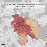
Within the project called Water in the city: Multidisciplinary approach to blue and green infrastructure, the University Center for Energy Efficient Buildings of CTU uses the ECOTEN company's thermal vulnerability map of cities as one of the sources of information. The results of the project should be used to identify exceptionally hot places with a lack of greenery and a high concentration of the population sensitive to heat waves, and in the preparation of other measures to protect residents from extreme weather conditions and ensure a suitable microclimate.
Under the term thermal vulnerability map is hidden the connection of various data on individual places in cities with accuracy down to blocks of houses, and in the case of population density, mostly at the level of neighborhoods, into one model. Air temperatures, population density sensitive to heat waves, i.e. older than 65 and younger than 14, and the occurrence of greenery are recorded. In order to determine the effects of future proposed measures, it is already necessary to use a 3D model of the city and apply microclimatic simulations that work with solar radiation, greenery, color and material characteristics, as well as with the directions and speeds of air flow.
Ensuring favorable climatic conditions in the city (pleasant temperature, humidity, etc.) contributes to improving the health and safety of the inhabitants and also has positive effects on their economic situation or cohesion. One way to ensure a suitable microclimate is generally to support blue and green infrastructure (water features and greenery) in cities, which lowers the temperature in public space through shading and evaporation.
Therefore, these maps are a valuable basis for the preparation of a manual for local government representatives, which should familiarize them with appropriate procedures for blue and green infrastructure designs. Thermal vulnerability maps for Písek and the Prague 4 district were used in the pilot phase.